
TODAY’S FRONT BRING SPOTTY RAIN CHANCES
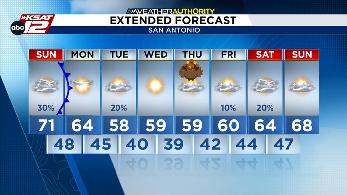
Heads up, a cold front is moving through the region, bringing a chance of scattered showers and a few isolated thunderstorms, especially near the Coastal Plains. Expect afternoon highs ranging from the low 60s in the Hill Country to the low-to-mid 70s further south and east. As the front passes, look for cooler temperatures and gusty north winds to move in, dropping us into the 60s by the evening. Stay weather aware!

COOLER AIR SETTLES IN
It looks like temperatures are dropping across the region this week! Be prepared for a chilly start to Thanksgiving week, with the coldest air settling into the Hill Country and the southern Edwards Plateau on Wednesday and Thursday. San Antonio could see a few areas drop into the 30s, and while a cold front on Tuesday might bring some light rain, most of the week looks to stay dry. Stay warm!

THANKSGIVING DAY
Expect a chilly start with temps in the 30s/40s, followed by sunny, cool afternoons. Dry weather should make for smooth holiday travel. Rain chances return this Sunday and briefly next Tuesday. Happy Thanksgiving!


